


Let's Invade Iran!
Part 1: Understanding Iran's Geography

I am a big fan of the Binkov's Battlegrounds channel where he explains the likely outcome of hypothetical wars. It’s a good way to get your head around military capabilities and operations.
However, Binkov doesn’t cover much in the way of how terrain effects warfare at the operational level, which I consider a bit of my bailiwick. Therefore I am going to have a stab at a Binkov type analysis of a hypothetical US invasion of Iran.
Because for some reason that keeps coming up as an option…..
In this first post I will take a wide view of Iran’s geography. In the next post I will look at Iran’s military to determine the appropriate size of a US invasion force.
Iran’s Geography - FLOCARK
Iran is a large country dominated by mountains and deserts. Below is a FLOCARK map, which my readers should be familiar with. If not here’s an explanation.

In FLOCARK you are supposed to draw in forests and mountains as green, because they have a similar effect in terms of canalizing defensive terrain. However, there isn’t an easy way to shade mountains in green on my mapping software. Instead I’ve added the grey relief shading overlay. So imagine the green sections and grey sections as having the same meaning.
Looking at this map you can see the Iran is nearly as mountainous as Afghanistan, but with a road network on par with Iraq’s. In fact, given the mountainous nature of the country it has a fairly well developed road network in the western half of the country, with most of the best roads going North/South. However, the road network is very sparse in the eastern half of the country. This means a successful invasion needs to be mounted out of Turkey, Iraq or from Persian gulf.
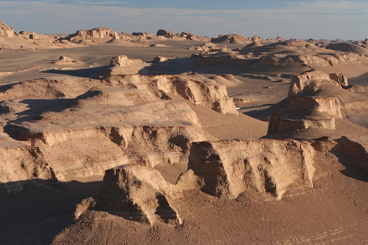
Iran has two areas of flat land: an empty desert in the east and arable farmland near the Iraqi border. That arable land is also the location of most of the oil fields.
Iran’s Geography - Size
I will compare Iran to three other countries that have been the subject of major wars in the 21st Century: Iraq, Afghanistan and Ukraine.
In terms of size and population, Iran is 2-3x large than the other three:

Iran is about the same population density as Ukraine and Afghanistan, which we accurately think of as somewhat sparsely populated countries in comparison to their size.
As another comparison, Iran is larger than Alaska and about 2.6x the size of Texas. Iran also has about the same population density as Texas, so that is a fairly good analogy.

In terms of military operations, what we’ve learned so far should be raising the first set of alarm bells. A US invasion of Iran fist came to prominence as part of George Bush’s Axis of Evil strategy, where Iran would be the next target after Afghanistan and then Iraq. However, as a military task invading Iran is a totally different ball game than Iraq or Afghanistan. By area those countries were about 3-4x smaller with 1/4 the population.
Iran’s Geography - Terrain Types
The terrain of Iran is a greater challenge than Iraq or Ukraine, but less than in Afghanistan. The best terrain for offensive operations is open terrain (prairies, rolling hills and farm land). That’s why it is the white area on a FLOCARK map. The best defensive terrain is mountains and cities, with the other type (woods, rural, small towns etc) being in the middle.
For all four of my comparison countries the urban area is less than 1%, so I have categorized the terrain types as Mountains for excellent defensive terrain, other for good defensive terrain and open for poor defensive terrain.

Based on these percentages you would rank these countries from easiest to hardest to invade as Ukraine, Iraq, Iran and finally Afghanistan. However, the situation is somewhat worse for Iran than it appears. Over 20% of it’s 32% open terrain consists of the deserts in the eastern half of the country.
Therefore in terms of where the battles are likely to occur Iran has approximately the same amount of excellent defensive terrain as Afghanistan (but it’s three times the size and population).
Iran’s Geography - Transportation Infrastructure
While terrain dictates the ease or difficulty of combat in a region, the ability to sustain offensive operations is dictated by the country’s transportation infrastructure. The chart below shows the density of the roads and railways in our four comparative countries. The measure is km of road per 100 square km of territory.

This graph understates the transportation density problem, because Ukraine at 28 km of road per 100 square km has a very poor transportation network by global standards. Here are the figures for a few other countries as context:

By this measure Iran, Iraq and Afghanistan are on par with the lesser developed African countries in terms of road infrastructure.
Despite the poor road network the US led coalition was able to manoeuvre and resupply fairly well during the 1991 Gulf war, and during the initial advance up to Baghdad during the 2003 invasion. This was mostly because they advanced across a type of hard sand desert that doesn’t require, provided you have the American style of truck heavy logistics system. This type of desert is much less common in Iran, and it is mostly in the eastern half of the country where significant fighting would not occur.
Conclusion
Although Iran is usually mentioned as an invasion target in the same context as Iran and Afghanistan, they are not comparable countries geographically. I compared Iran to Iraq, Afghanistan and Ukraine and concluded that:
Iran has 3-4 times the size and population of the other three countries, so an invasion of Iran would be on a different scale;
Looking at the areas where combat would occur, Iran has about the same amount of excellent defensive terrain in the form of mountains as Afghanistan; and
Iran has the same transportation infrastructure density as Iraq. This is quite poor as both countries have figures that would be low for an African country. Therefore any invasion would face significant logistic hurdles.
In the next episode I will look at the Iranian military, in order to determine what sized invasion force the United States would need to assemble.
We won't invade. American leaders are cowards and now the American people won't sign up to die in Israel's war. So, we will just bomb them. We may even use low yield nuclear weapons but we won't invade.
America is absolutely the worse kind of super power. An ideological evangelist state that grew up in an extremely safe neighborhood where it never had any real threats. Such an environment giving both an extreme amount of immunity from the consequences of our actions and an appalling lack of a cultural understanding of war one gets from the cultural memory of soldiers who go off to fight a war only to come home to their burnt out city and slaughtered family.
We need to fall apart before we.destroy the world.
Interesting article. Thanks for looking into it. Are aircraft an option for logistics, or is it still limited? Also is there a rail network that could be used?